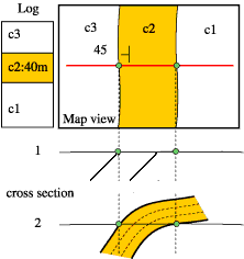
| The map below tell us that the western boundary of the unit c2 dips 45º to the west. The log gives the thickness of c2. To reconciliate the surface outcrop of c2 (area in between the two green dots) with the thickness of the layer we have no choice but to assume that the layer is folded. The cross section 2 is consistent with all informations provided. |
|
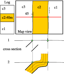
After more fieldwork it turns out that the eastern boundary of c2 is vertical. This information invalidates the former cross-section, which must be modified. A change in the fold style allows us to construct a valid cross-section. The cross-section assumes that the thickness of c2 keeps constant. |
|
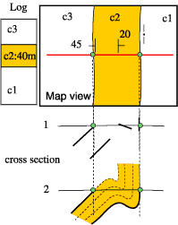
After more fieldwork, an additional strike-dip is provided inside c2. This additional information invalides our former cross-section. This new information implies a different style of folding. This cross-section is consistent with all the information provided. |
|
|