


| PRACTICAL 1: TOPOGRAPHIC CONTOURS, STRUCTURAL CONTOURS AND GEOLOGICAL MAPS. | |
|
|
|||||||||
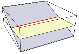
| We are now considering geological surfaces instead of the topographic surface. Here again the problem is to represent, in 2D, a 3D geological surface. | In a similar fashion as for topographic contours, we replace the 3D geological surface by a bunch of contours called structural contours. Structural contours joint points on the geological surface that have the same elevation. A structural contour can be defined as the intersection between the geological surface and an horizontal plane. | |||||||||||
|
||||||||||||
|
||||||||||||
|
||||||||||||
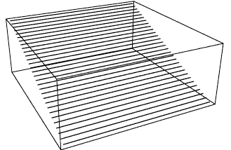
| On the right is a set of structural contours. The difference in elevation between two sucessive structural contours is constant. This image gives a good approximation of the 3D topographic surface, but it is still a 3D document. The orthogonal projection of these structural contours onto a horizontal surface gives a 2D structural map, that carries all the information necessary to recover the initial 3D geometry. | ||||||||||||